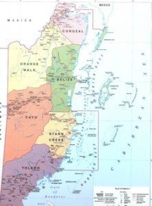
 Belize is both Central America and the Caribbean. So it has the advantages of both.On the North of Belize is Mexico and one the west and south it is Guatemala. And on the east it is the Caribbean Sea. Just off the coast of Belize is the second-longest barrier reef in the world. It’s about 240 miles long and is surrounded by hundreds of Cayes (pronounced keys by the residents of Belize).
The Belize coast is lined with that coral reef and over 450 Cayes (islets and islands). They total about 266 square miles and form the approximately 200 mile long Barrier Reef. It is the longest in the Western Hemisphere and the second longest in the world after the Great Barrier Reef. Three of only four coral atolls in the Western Hemisphere are located off the coast of Belize. The most well known is probably The Blue Hole.
Belize is not a big country. It is the second smallest in Central America (after San Salvador) and is about 8,865 square miles in area (about the size of Massachusetts.) There are a number of lagoons along the coast and the interior so actual land reduces that by about 6,000 square miles.
Belize is shaped like a rectangle that extends about 174 miles going north-south and about 62 miles going east-west. There are two large winding rivers, the Hondo and the Sarstoon, that setup much of the country’s northern and southern boundaries. The western border follows no natural features and runs north-south through lowland forest and highland plateau. The north of Belize consists mostly of flat, swampy coastal plains, in places heavily forested. The south contains the low mountain range of the Maya Mountains. The highest point in Belize is Doyle’s Delight at 3,688 feet.
Belize has set aside nearly half (about 48%) of the country as ecological preserves and nature parks. The mainland has highly diverse flora considering the small geographical area.
